![]()
 |
|
Intro | Map | Downloading the app | Instructions | Safety | Frequently asked questions | Downloading the data | Credits & Contact
Why care about roadkill data?
Why did the bear cross the road? To get to the other side is the common answer. But as we dig into that, we realize there is more to it than that. All animals need food, water, shelter and access to mates. Some movement across the road, particularly among species with big home ranges, is to meet these basic needs. Different food sources are available in different spots at different times of year. So, some species move around a lot to get what they need. A black bear might utilize lower elevation wetlands in the spring, as they are home to some of the first plants to green up. In the summer they might eat berries in open meadows and in the fall gorge on beech nuts and acorns up on the ridges. That might take them across many roads over the course of a year and they’ll use several forest blocks. A single black bear can have a home range of 10,000 to 20,000 acres. Similarly, radio tracking data from the Champlain Valley shows male bobcats have a 27-mile home range, moving approximately 19 miles each day.
Some movement is annual migration. Each spring salamanders emerge from underground in forested uplands and move downslope (often across a road) to wetlands where they breed and then head back up the hill. This is a movement of perhaps only 600 feet, but in places where this happens, thousands of animals might cross a road in a single night in the spring.
Additionally, many species are adjusting their home ranges in response to a warming climate. The Nature Conservancy estimates entire populations are moving north and south away from the equator at about 1 mile per year. That’s entire populations adjusting their ranges! In Vermont, that movement is not just south to north. Wildlife crossing usually happens where wetlands and forests are close to both sides of the road. Where streams and rivers go under the road can be an excellent spot for wildlife crossing and many of our bridges and culverts do facilitate that kind of movement. Some structures, particularly older ones often do not.
Thinking about wildlife movement leads us to thinking about habitat connectivity; the network of connected waters and forests across the state that allow for animals to move around to meet their needs now and into the future. Roadkill tells us where our road system is still acting as a barrier and can be helpful information to fish & wildlife and transportation managers about spots where improvement is necessary. In some cases that could mean enlarging nearby bridges or culverts to allow for under the road movement. Please help us learn more about where wildlife are crossing roads by using this Roadkill Observation and Data System (ROaDS) system to report roadkill and animals close to the road.
To learn more, visit BioFinder to see the map of connected forest blocks, surface waters and riparian areas and wildlife road crossings.
Roadkill data collected since January 2022
This is a regularly-updated map of roadkill and animal collision incidents across the Northeast United States and Southeast Canada.
Instructions for loading the collector App onto your phone or Tablet
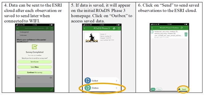
Anyone can upload roadkill or animal collision incidents to the ROaDS database. To get started:
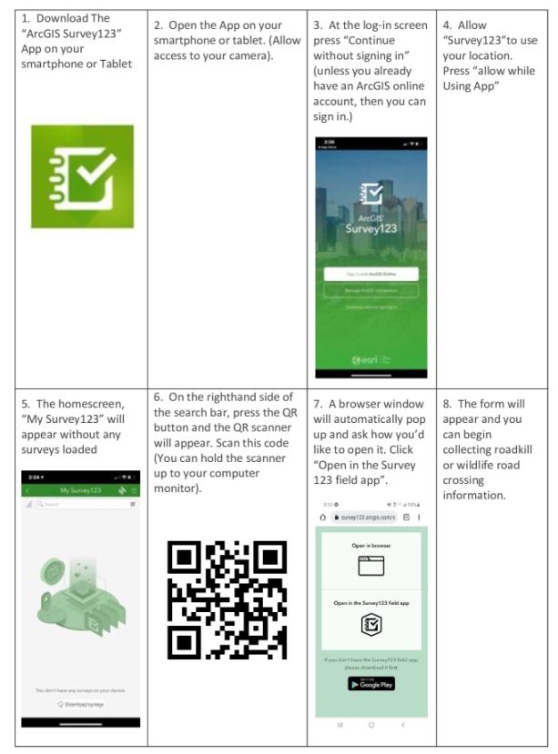
How to use the Survey 123 Form
Once you have downloaded the Survey 123 App and used the QR code to get the ROaDS form loaded, you are ready to start using the system.
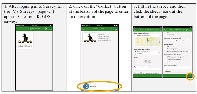
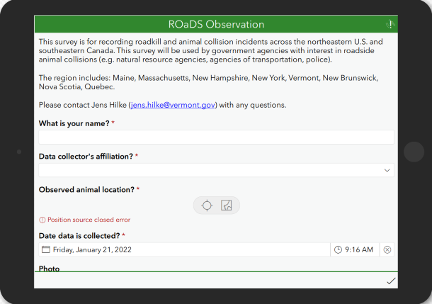
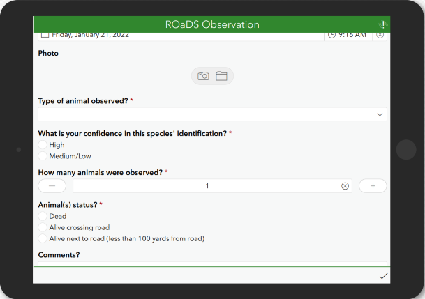
Here’s the survey form that you’ll be using.
Staying safe while collecting roadkill data
Driver and pedestrian safety is the most important priority when collecting data. Members of the public wishing to report a roadkill incident should not collect data while driving. Make note of the location and species while driving by at an appropriate speed. Enter data only when in a safe location and with the vehicle stopped, Never pull over on the side of interstates and state routes. Use only established parking areas. When entering location data, the pin defaults to the current location but can be changed. The only time a picture should be taken is if the photographer is prepared with appropriate reflective gear and on a less-traveled road with safe access to the carcass. Do not touch injured or dead animals.
Once the roadkill incident has been reported in the ROaDS survey, please contact the local VT Department of Transportation (VTrans) Garage at 802-917-2458 if assistance is required to remove the animal. For additional information on Roadkill Safety, follow this link
Frequently asked questions (FAQ)
What happens to the photos I take of roadkill?
-
All photos are uploaded directly to our website and live map of roadkill incidents across the region. Photos taken within the Survey123 app do not get saved to your personal camera roll. If you would like to keep your photos, either take a second photo of the roadkill on your phone camera or contact jens.hilke@vermont.gov to have your photos emailed to you.
Why can’t I upload a saved photo on my phone to the ROaDS survey?
-
For IOS and iPhone users, open “Settings” on your device and scroll to Survey123. In “Permissions,” change photo access to “All Photos.” If this doesn’t work, try updating your IOS device and relaunching Survey123.
What happens once I’ve submitted my survey response?
-
Responses are anonymously displayed on our website, with all sensitive information removed (respondent name, additional comments, etc.). Your full response is stored for use by the Vermont Agency of Natural Resources and partners working to understand wildlife movement across the Northern Appalachian region.
Can I upload a survey response if I am offline?
-
You can store your survey responses offline in your Survey123 app until you are back in service. Once you are back online, you can upload all your responses through the app.
What if I can’t identify the animal?
-
At the bottom of the list of species, there are options for “Other mammal,” “Other reptile or amphibian,” and “Bird, other.” Please select which class most accurately reflects your roadkill find. You can leave comments at the bottom of the survey to further explain your submission.
-
The Comments field is not public facing, but the other fields all appear on the map. Information about rare and endangereed animals can be mentioned in the comments field and not made public to protect sensitive species.
How to download the ROaDS database (for partnering organizations)
- ROaDS Analysis Manual
- ROaDS Installation manual (For other jurisdictions wishing to establish their own roadkill reporting system on ArcGIS online)
Credits & Contact
The form and structure used in Vermont’s roadkill reporting system is based on the Roadkill Observation and Data System (ROaDS), created by the National Park Service, the U.S. Fish and Wildlife Service and Western Transportation Institute at Montana State University. Thanks to these partners for making this available to us! Please contact Jens Hilke (jens.hilke@vermont.gov), Conservation Planning Biologist, with any questions.
![]()
![]()
![]()